NSW · South East and Tablelands · Regional
Eurobodalla Shire Council
A zone sets what may be built on the land — houses, apartments, shops, industry — and what may not. The zoning of Eurobodalla Shire Council, drawn from NSW’s own Land Zoning Map: every zone, where it applies and how much land it covers.
1.3% of Eurobodalla Shire Council is zoned residential.
Zoned by the Eurobodalla Local Environmental Plan 2012
Zoning map
Every zone, from NSW’s own map
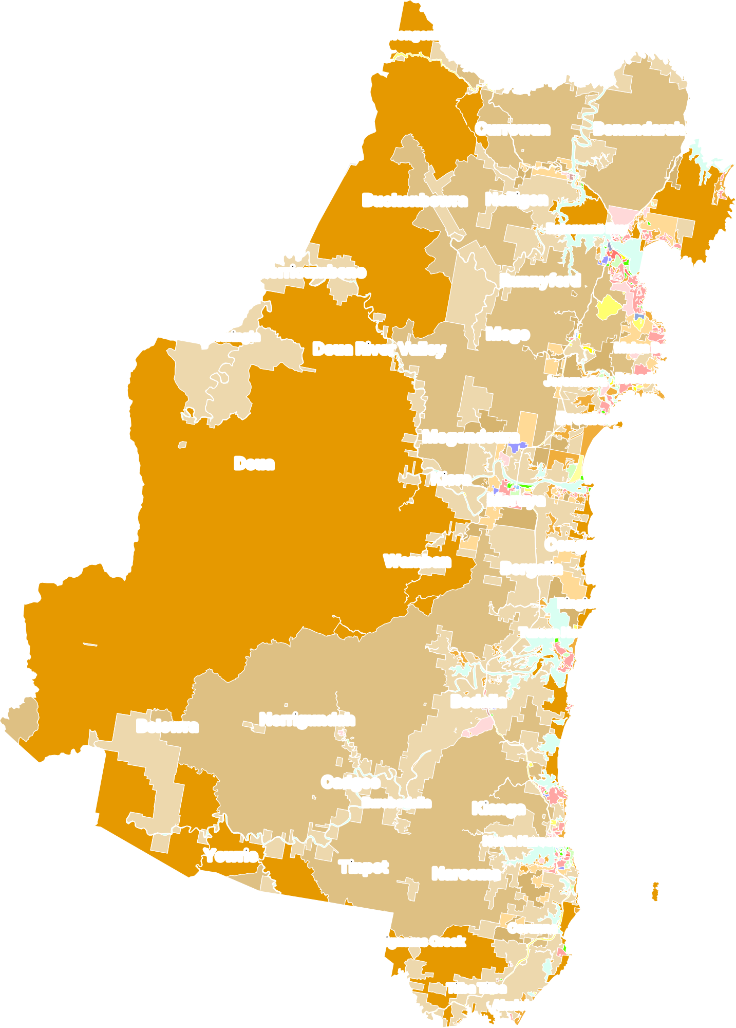
21 zones and the land each covers
Residential4,306 ha1.3%
- R2 Low Density Residential2,661 ha0.8%
- R3 Medium Density Residential246 haunder 0.1%
- R5 Large Lot Residential1,399 ha0.4%
Employment and mixed use470 ha0.1%
- E1 Local Centre56.8 haunder 0.1%
- E3 Productivity Support54 haunder 0.1%
- E4 General Industrial335 haunder 0.1%
- MU1 Mixed Use23.9 haunder 0.1%
Special purpose1,705 ha0.5%
- SP1 Special Activities140 haunder 0.1%
- SP2 Infrastructure1,460 ha0.4%
- SP3 Tourist106 haunder 0.1%
Recreation746 ha0.2%
- RE1 Public Recreation311 haunder 0.1%
- RE2 Private Recreation435 ha0.1%
Rural176,796 ha52%
- RU1 Primary Production63,799 ha19%
- RU3 Forestry106,973 ha31%
- RU4 Primary Production Small Lots5,931 ha1.7%
- RU5 Village92.2 haunder 0.1%
Conservation150,420 ha44%
- C1 National Parks and Nature Reserves139,984 ha41%
- C2 Environmental Conservation4,861 ha1.4%
- C4 Environmental Living5,574 ha1.6%
Waterways8,654 ha2.5%
- W1 Natural Waterways8,610 ha2.5%
- W2 Recreational Waterways44.4 haunder 0.1%
Where it comes from
The plans that zone Eurobodalla
- Eurobodalla Local Environmental Plan 2012The council's local environmental plan100%
A planning proposal under way can change this map. See Eurobodalla’s planning proposals.
The latest changes NSW published to the map
- Eurobodalla Local Environmental Plan 2012 — Map Amendment No 131 Oct 2025
- Eurobodalla Local Environmental Plan 2012 — Amendment No 197 June 2024
- State Environmental Planning Policy Amendment (Land Use Zones) 202324 Feb 2023
Every lot’s controls
Across NSW, 0.7% of the zoned land is residential.
Lodgd holds the zone, height limit, floor space ratio and heritage of every lot in NSW — beside the development applications, CDCs and building certificates on it, and the homes each council’s zoning already allows.
Try the free demo →Measured over the zoning maps of all 128 councils: 70,858,225 hectares zoned, 482,381 of them residential (zones R1 to R5).
Of every hundred hectares NSW’s councils have zoned, this much is zoned residential.
Elsewhere in NSW
Zoning in other councils
How the system works. How land is rezoned · Transport-oriented precincts · All guides →
How we measure. Every zone NSW’s Land Zoning Map draws in Eurobodalla Shire Council — the council’s own plan, and the land State planning policies zone directly — as NSW publishes it. Areas are measured from NSW’s outlines; shares are of the land NSW’s map zones, waterways included. Zoned residential means zones R1 to R5, and the older residential zones a few State policies still use.